 |
PROVINCE OF EASTERN
SAMAR

The province of Eastern Samar was
created by Republic Act no. 4221 which was approved by Congress on June
19, 1965 dividing the whole island of Samar into three independent
provinces namely; Northern Samar, Western Samar (subsequently renamed
Samar) and Eastern Samar. As embodied in this Act, the eastern province is
composed of 23 municipalites with Borongan as the capital.
In the 1967 general elections, the newly independent province elected its
first set of officials. The provincial board has its inaugural session on
January 2, 1968 at the Borongan Town Hall. But it was not until September
7 of the same year when the new province was inaugurated in a simple but
impressive ceremony at Borongan town plaza.
Before it existence as an independent province, places which now form part
of Eastern Samar played important roles in the history of our country.
On March 16, 1521, Magellan first set foot on Philippine soil on the
island of Homonhon on his way to rediscover the Philippines for the
western world.
An American garrison of occupation troops was annihilated by the
townspeople of Balangiga on September 28, 1901. Now known in history as
the "Balangiga Massacre", this incident triggered a wave of reprisal
against the people of the whole island of Samar.
On October 17, 1944, rangers of the U.S. Army landed on the tiny island of
Suluan, Guiuan and had their first encounter on territory three days
before Gen. Douglas Macarthur landed on the beaches of Leyte.
Earliest known chronicles reveal that further contact with Western
civilization aside from the Magellan landing occurred as early as 1596
when Jesuit missionaries worked their way from the western coast of the
island of Samar and established mission centers and established mission
centers in what is now as Eastern Sam territory. It is most probable that
the populated existing settlement were created pueblos shortly after this
time. The eastern part of the island was known as Ibabao and distinct from
Samar which was the name of the western part. Magellan called the place
where he landed at Homonhon Island "The Watering Place of Good Signs".
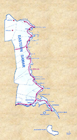
LOCATION
Eastern Samar is bounded on the east by the
Philippine Sea, which forms part of a greater body of water, the Pacific
Ocean. To the north lies Northern Samar; to the west, the province of
Samar; and to the south, the Leyte Gulf. Eastern Samar has 23
municipalities. Borongan, the provincial capital, lies some 550-air
kilometers southeast of Manila and roughly 65-air kilometers northwest of
Tacloban City, the capital of Eastern Visayas. AREA Eastern Samar has a
total land area of 4,339.60 square kilometers. It measures approximately
150 kms. From northern boundaries of Jipapad where it abuts Northern Samar
to the tip of Sungi point in Guiuan, the southernmost point of it lands
body. It is approximately 40 kms. at its widest point. Borongan, the
capital, is the largest municipality in terms of area. The largest island
is Homonhon in Guiuan with approximate land area of 105 sq. kms.
Table 1. Status of Land Classification Land Classification 1985 1986-1994
Alienable and Disposable Land a/ 447,075 447,075 Total Forest Land 201,375
201,375 Unclassified Forest Land 245,700 245,700 Classified Forest land
239,166 Forest Reserves 6,534 245,700 Timberland b/ 5,788 5,788 National
Parks 238,401 Military Reservation Civil Reservation 746 746 Fishpond
Development 765 - a/ includes certified and proposed alienable and
disposable lands - b/ includes certified and proposed timber lands Note:
1. The Land Evaluation Party (LEP) made no reclassification since 1986.
Hence, data from this year up to present did not change. 2. Data may not
equal to the regional and provincial figures produced by the
Philippine-German Resources Inventory Project in 1987 since their data
were estimates only based on LANSAT images/interpretation while the data
reflected in this table were based on cadastral survey of LEP. Source:
Department of Environment and Natural Resources, Region VIII
Table 2. Land Area by Municipality Municipality A & D Forestland Total
Arteche 8,912.0 6,014.0 14,926.0 Balangiga 6,407.9 11,343.7 17,751.6
Balangkayan 2,458.0 6,752.0 9,210.0 Borongan 12,989.9 45,802.0 58,791.9
Can-avid 8,755.0 15,253.0 24,028.0 Dolores 11,504.0 12,648.0 24,152.0 Gen.
MacArthur 4,012.0 4,226.0 8,238.0 Giporlos 5,277.7 2,651.3 7,929.0 Guiuan
4,340.0 13,005.0 17,345.0 Hernani 2,604.0 2,207.0 4,811.0 Jipapad 6,297.0
14,033.0 20,330.0 Lawaan 5,928.0 8,057.3 13,985.3 Llorente 5,474.0
40,072.0 45,546.0 Maslog - 31,885.0 31,885.0 Maydolong 3,950.0 18,608.0
22,558.0 Mercedes 2,082.0 250.0 2,332.0 Oras 5,712.0 15,723.0 21,435.0
Quinapondan 4,886.0 2,523.0 7,409.5 Salcedo 10,546.0 1,114.0 11,660 San
Julian 3,157.8 8,255.0 11,413.0 San Policarpo 6,405.0 650.0 7,055.0 Sulat
5,223.2 10,178.8 15,402.0 Taft 5,716.0 13,524.0 19,240.0 Total 136,657.50
284,775.8 417,433.3 % Total 31.78% 62.22% 100.00
TOPOGRAPHY
The interior part of the province is rough and hilly and covered
with dense tropical vegetation but drained by numerous rivers and creeks.
Mountain ranges and peaks abound in an interior. The highest among them
located at the northwestern part of the province is at 783 meters above
sea level. Narrow plains hug most of the coastal areas and in some
instances the banks of its principal rivers and their tributaries. Most of
the coastal towns are located on narrow deltaic plains. The widest
contiguous plain on relatively level ground lies west of the poblacion of
Dolores near the southern banks of the Dolores River. Another smaller
plain is located at the municipality of Quinapondan.
Table 3. Slope Classification SLOPE AREA PERCENT SHARE < 8% 1,041.7 23.3 8
- 18% 697.4 15.6 18 - 30% 1,381.5 30.9 30 - 50% 1,314.4 29.4 > 50% 35.8
0.8 TOTAL 4,470.8 100 CLIMATE The climate of the province falls under type
"E" category with all months having 61 mm. (2.4") rainfall or more.
Although the climate is characterized by rain and marked seasonal period
of heavy precipitation at all months of the year, it shows distinct
seasons: rainy from November to January with northeast monsoon as the
prevailing wind and dry from July to September with its westerly winds
locally called "habagat" as the prevailing wind.
Table 4. Climatic Indicators INDICATORS ANNUAL Average Output of Rainfall
3,146.6 Number of Rainy Days 192.0 Mean Temperature 26.8 C Minimum
Temperature 22.9 C Maximum Temperature 30.8 C Relative Temperature 85.0
Prevailing Temperature NE/2
POPULATION
Eastern Samar has a population of 58,285 and a population density
of 129.14 per square kilometer.
Table 5. Total Population and Number of Household MUNICIPALITY TOTAL
POPULATION NO. OF HOUSEHOLD Arteche 12,538 2,370 Balangiga 11,100 2,053
Balangkayan 8,849 1,679 Borongan 48,638 9,553 Can-avid 15,759 2,792
Dolores 34,272 6,073 Gen. MacArthur 10,041 1,807 Giporlos 10,050 1,889
Guiuan 35,447 7,058 Hernani 8,055 1,339 Jipapad 6,222 1,059 Lawaan 9,725
1,657 Llorente 16,071 3,320 Maslog 3,634 689 Maydolong 12,201 2,112
Mercedes 5,473 888 Oras 31,533 5,692 Quinapondan 12,644 2,023 Salcedo
16,026 3,254 San Julian 11,858 2,398 San Policarpo 11,565 2218 Sulat
14,010 2,710 Taft 16,613 2,946 Total 362,324 67,579
POLITICAL SUBDIVISIONS
The 23 municipalities composing the province are Jipapad, Arteche,
San Policarpo, Oras, Maslog, Dolores, Can-avid, Taft, Sulat, San Julian,
Borongan, Maydolong, Balangkayan, Llorente, Hernani, Maydolong,
Balangkayan, Giporlos, Lawa-an, Balangiga, Mercedes, and Guiuan. Jipapad
and Maslog are interior municipalities with all the rest are located along
the coastal areas. The province has a total of 595 barangays. Borongan has
the biggest number of barangays with 61 and closely followed by Guiuan
with 60 and Dolores as third with 46. Conversely, those with the least
number are Maslog with 12 and Balangiga, Hernani and Jipapad with 13 each.
Table 6. Dates of Creation of Municipalities and no. of Barangays
MUNICIPALITY DATE/"PUEBLOS"/MUNICIPALITY AUTHORITY NO. OF BRGY. PERCENT
SHARE Arteche April 27, 1951 R.A. No. 607 20 3.4 Balangiga April 3, 1854
Royal Orde2r 13 2.2 Balangkayan May 2,1959 R.A. No. 2181 15 2.5 Borongan
61 10.2 Can-avid July 04, 1948 R.A. no. 264 28 4.7 Dolores April 5, 1864
Royal Order 46 7.7 Gen. MacArthur June 22, 1949 R.A. No. 225 30 5 Giporlos
August 9, 1949 E.O. No. 225 18 3 Guiuan 60 10.1 Hernani January 4, 1864
Royal Order 13 2.2 Jipapad June 16, 1965 E.O. No. 157 13 22 Lawaan May 7,
1959 R.A. No. 2185 2.2 27 Llorente May 14, 1851 Royal Order 2.7 5.5 Maslog
June 19, 1965 R. A. No. 4221 2.0 20 Maydolong May 1, 1955 R.A. No. 609 2.0
3.4 Mercedes June 10, 1864 Royal Order 3.4 27 Nov. 1848 Royal Order 2.7 61
Oras 1850 Royal Order 6.9 42 Quinapondan 1854 Royal Order 4.2 4.2 Salcedo
Dec. 5, 1864 Royal Order 4.2 7 San Julian July 4, 1863 Royal Order 27 2.7
San Policarpo June 14, 1948 R.A. no 281 2.8 2.8 Sulat 18 3.0 2.8 Taft 24 4
4
|
