 |
PROVINCE OF BILIRAN

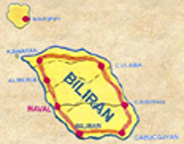
LOCATION
Situated in the heart of the Philippines, Biliran Island is 1,115
kilometers southwest of Manila. An island province, it is bounded by the
Visayan Sea on the north, Carigara Bay on the south, Samar Sea on the east
and the Strait of Biliran on the west. It is part of the Eastern Visayas
Region or Region VIII.
AREA
Biliran has a total land area of 55,542 hectares, approximately 60%
(33,192 ha.) is considered alienable and disposable while the remaining
(22,350 ha.) is made of forestland. The land is utilized as follows:
33,263 ha. agricultural; 339.01 ha. residential; 4.76 ha. commercial; 0.48
ha. industrial and 18,581.75 ha. forestland. The rest are idle lands
Table 1. Status of Land Classification LAND CLASSIFICATION 1986-1994
Alienable and Disposable Land a/ 33,192 Total Forest Land 22,350
Unclassified Forest Land Classified Forest land 18,581.75 Agricultural
33,263 Residential 339.01 Commercial 4.76 Industrial 0.48 Civil
Reservation - Fishpond Development - Table 2. Land Area by Municipality
MUNICIPALITY Land Area (sq.km) Almeria 65.5 Biliran 70.3 Cabucgayan 49.4
Caibiran 83.6 Culaba 73.4 Kawayan 44.7 Naval 71.0 Maripipi 27.8 Table 3.
Status of Irrigation System TOTAL ARABLE AREA POTENTIAL IRRIGABLE AREA
EXISTING SERVICE AREA 28,152 (has.) 5,664 (Has.) 3,301 (HAS) POLITICAL
SUBDIVISIONS Table 4. List of Municipalities and Barangays Municipality
Number of barangays Almeria 13 Biliran 11 Cabucgayan 13 Caibiran 17 Culaba
17 Kawayan 20 Naval 26 Maripipi 15 Total 132
Biliran has a total land area of 555.42-sq. km. constituting about 8.86%
of the whole Eastern Visayas Region (Region 8). It has eight
municipalities namely: Naval - the capital town, Almeria, Kawayan, Culaba,
Caibiran, Cabucgayan, Biliran and maripipi. It has 132 barangays. Seven of
its municipalities are classified as coastal while the eight, Maripipi, is
an island municipality. The province is represented in the Philippine
Congress as a lone district.
TOPOGRAPHY
Biliran's topography ranges from slightly flat to gently rolling
terrain. It has coastal lowland with mountainous interior except for the
municipalities of Naval and Caibiran, which have wider plains and rolling
terrain approximately 7 kilometers from the coast. Mountain ranges occupy
the major portion of the island municipality of Maripipi.
CLIMATE
The Climate of the province belongs to the Type II according to the
Climate Map of the Philippines. Located near the eastern coast, Biliran
Island does not experience a prolonged dry season. It has very pronounced
rainfall, 500mm during December which subsides in January, and minimum
rainfall of 150 mm in April.
POPULATION
Based on the 1995 census, the total population of the province is 132,209.
The province also has a total of 25,646 households, and a household
population of 132,126 (excluding temporary residents and transients). It
has a population density of 238.03 persons per sq. km., With a life
expectancy of 60 to 65 years old. Among the six provinces of Region 8,
Biliran registered the smallest population.
Table 5. Total Population and Number of Household Municipality Total
Population No. of Households Almeria 13,420 2,627 Biliran 13,775 2,451
Cabucgayan 16,498 3,147 Caibiran 18,582 3,480 Culaba 12,703 2,119 Kawayan
16,424 3,402 Naval 32,954 6,866 Maripipi 7,853 1,554 Total 132,209 25,646
Source: NSO Table 6. PROVINCIAL SITUATIONER (CY '97-JUNE 1998) COMMODITY
(1) AVAILABLE SUPPLY (MT) (2) CONSUMPTION (MT) (3) SUFFICIENCY LEVEL (%)
(2)/ (3)= (4) RICE 25,386.08 15,054.64 1.68% WHITE CORN 895.05 0.38%
VEGETABLES 570.92 5,156.15 0.11% ROOTCROP/Tubers 1,267.68 2,782.99 0.46%
PORK 654 831 78% BEEF 67 116 57% CARABEEF 73 211 34% CHICKEN MEAT 280 534
52% FISH 2271.33 (2,488.19) FRUITS 7,562.33 3,701.85 2.04% CHICKEN EGGS -
- -
DIALECTS
Cebuano, spoken by 57.79 percent of the population, and Waray-waray by
40.80 percent, are the major dialects spoken in the island. The towns
facing the mainland of Leyte and Samar speak Waray-waray, whereas the
towns near Cebu speak the Cebuano dialects. Filipino/Tagalog and English
are also spoken and understood by most of the inhabitants.
BANKING
There are 3 banks operating in Biliran namely, the Philippine National
Bank, Land Bank of the Philippines, and the Rural Bank of Naval.
COMMUNICATION
All the 8 municipalities have post offices. RCPI and PT & T provide
telegraph-services. Eight Municipal Telephone Public Office (MTPO) enable
domestic calls from each municipality. Bayan Tel and PLDT calling offices
provide fax transfer and long distance telephone calls. MTPO-Naval now
accepts international calls. One LBC office operates in Naval, Biliran.
The province has access also to national and regional dailies, aside from
its own monthly government publication.
WATER AND POWER
About 89.46 percent of the population have access to water service while
10.64 percent draw water from artesian/deepwell. About 72 percent of the
barangays and 62 percent of the total households are energized. Power
comes from NPC in Tongonan, Ormoc. Distribution is facilitated by the
Biliran Electric Cooperative (Bileco). Power rate is Php.4.76 per kwh.
BRIEF HISTORY
In the early Spanish time, the island was known as Isla de Panamao.
Panamao referred to an ethnic fishing net. Panamao Island was the site of
the first large-scale Spanish shipyard in the Philippines. But somehow
between 1668-1712, the name Panamao was changed to Biliran, a name derived
from a native grass called "borobiliran" which grew abundantly on the
plains.
On April 8, 1959, Republic Act No. 2141 made Biliran a sub-province of
Leyte. The Lt. Governors who served Biliran include Hon. Uldarico Reyes
(1959-1963), Hon. Jorge Zamora (1963-1967), and Hon Uldarico Reyes (-1967
- 1971).
The corporate system of governance was conceptualized to realize the
vision of a totally empowered Biliranon, living in an ecoligically
balanced community, where there is justice, peace and prosperity.
National government agencies, non-government agencies, organizations and
people's organization are enjoined by the provincial government to take
part in the noble task of building a province and a people, and accomplish
the mission to empower a every Biliranon for the total development of
Biliran.
AGRICULTURAL SCENARIO
Biliran's economy can be classified as predominantly agricultural having a
total agricultural hectarage of 33,263 ha. or roughly 60% of the total
land area of the province. In 1996, approximately 153,093.48 mt of various
agricultural products valued at P918,560,880 were produced from these
areas.
PALAY. Palay is planted to 6,673.55 ha. by 4,521 farmers. Of the total
area devoted to rice, 6,569.43 ha are lowland and 104.12 ha are upland.
Total palay production is 49,739.72 mt per year for two cropping seasons.
Average production per cropping is 80 cavans per hectare. Postharvest
facilities available include: 77 rice mills, 15 warehouses and two
mechanical dryers. The construction of a new irrigation system is underway
and is implemented by the provincial government to support the rice
industry.
CORN. An area of 202.57 ha. is devoted to corn production which has an
average production capacity of 1.0 mt/ha. Postharvest facilities available
are two units of corn grinder.
COCONUT. Coconut is widely planted in the province which covers an area of
22,195.60 ha. involving around 20,634 full time and part time farmers.
Total copra production in 1995 was estimated at 28,107 mt. With a
conservative assumption of P7.00/kg of copra, the production value of this
crop was estimated to be P196,749,000.00 for the said year.
There are around 80 copra consolidators (of various sizes) who play a
major role in this industry. Likewise, coconut lumber as by-product is an
alternative source of lumber for the province with 23 total registered
coco-lumber processors and 11 coco-lumber dealers.
VEGETABLES. Production of locally grown vegetables (e.g. eggplant,
carrots, cabbage, pechay) totaled 125.90 mt in 1995 which was planted to
an area of 58.60 ha.
ROOTCROPS. Rootcrop production totated 4,061 mt which covered a planting
area of 616.29 ha. Some rootcrops grown in the area are camote, cassava,
ubi, and gabi.
FRUITS. Some 125.075 ha are planted to various fruit trees (e.g. bananas,
jackfruit, guavas) in the province. Average production is 5 mt/ha or a
total production of 628.75 mt. Banana is a major fruit grown in the
province. Assorted varieties of bananas are planted either along roads,
inter-cropped with coconut or found growing in the wild. Total area
covered by this crop is 3,109.54 ha. Dominantly produced banana is the
Cardava variety. An estimated harvest of three (3) trucoloads are being
shipped to Metro Manila every week.
LIVESTOCK AND POULTRY. The province has an inventory of 2,665 heads of
cattle; 4,940 carabaos; 21,762 hogs; 2,170 goats; 45,369 chicken; and
5,719 ducks. No commercial raisers of these animals exist in the province.
All are classified as backyard raisers.
FORESTRY PRODUCTION. The forest lands include 25,796 ha. located in five
watersheds. Around 548 ha. is considered virgin forest. Forest production
consists of natural and plantation forest. Denuded forests that need
reforestation activities cover an area of 14,907 ha.
FISHERY. Inland Fishery and Aquaculture. Municipal fishery accounted for
1,721.64 mt of fish produced in 1995. There are 104.7 ha of brackish water
fishponds available of which 59.06 are developed. Total fishpond
production was 97.5 mt of prawns, shrimps and milkfish. The number of
commercial and municipal fishing boats are 35 and 448, respectively, while
there are 562 motorized and 1,518 non-motorized bancas.
Deepsea Fishing and Marine Culture. There are 11 deep-sea fishing
operators with an annual catch of 432.22 mt. Around 30 ha. of sea water
are suitable for seaweed farming and another 10 ha for fishcage culture.
|
