A { TEXT-DECORATION: none } A:hover { TEXT-DECORATION: underline }


LOCATION

Eastern part of Visayas

LAND AREA (hectares)

2,143,159
Certified Alienable & Disposable land
1,083,947 (50.6% of the region's land area)
Forest land
1,059,212(49.4% of the region's land area)

TOPOGRAPHY

The region's terrain is relatively flat near and along the coast. Its mountainous areas are mostly located in the middle portion of Samar and Leyte. Leyte's mountainous terrain covers most of the southern and southwestern portion of the island while the northern part is extensively flat. At the northwest part are scattered coastal flat lands. Samar, on the other hand, is characterized by mountainous ranges with forest and deep valleys. It has four major river basins. These are the Gandara, Catubig, Dolores and Ulot River Basins.

PROVINCES

Biliran, Leyte, Southern Leyte, Eastern Samar, Northern Samar & Western Samar

NO. OF MUNICIPALITIES / CITY

140 / 3

NO. OF BARANGAYS

4,390

POPULATION (1995)

3,366,917

CLIMATE

The region has an evenly distributed rainfall throughout the year. Pronounced maximum rainfall is experienced from November to January while a relatively dry season is experienced in the months of April until August.

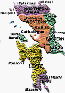
POPULATION, MUNICIPALITIES/CITIES AND BARANGAYS

Province

Capital

Population
(1995 Census)

Number of Municipalities & Cities

Number of Barangays

Biliran Naval 132,209 8 132
Leyte Tacloban City 1,511,251 41/2 1,641
Southern Leyte Maasin 317,565 19 500
Eastern Samar Borongan 362,324 23 597
Northern Samar Catarman 454,195 24 569
Western Samar Catbalogan 589,373 25/1 951
Total  3,366,917 140/3 4,390


Biliran  |  Leyte  |  Southern Leyte  |  Eastern Samar  |  Northern Samar  |  Western Samar  |


|  Copyright © 2002 by Department of Agriculture - Regional Field Unit VIII  |  All rights reserved  |